A good site plan is the single most useful document at an outdoor event. The crew use it to build the site, the safety officer uses it to check routes and exits, the council and emergency services use it to judge your arrangements, and on the day it tells everyone where things are. A poor plan, or three different versions of one, causes confusion before the first truck arrives.
This guide covers what to put on an event site plan, how to draw one that works, and who needs which version.
Start with an accurate base map
Your plan is only as good as the map underneath it. For a field or park, an aerial image or Ordnance Survey-based map is a good start, but always walk the site yourself. Note slopes, soft or boggy ground, overhead power lines, trees, drains, manholes, gates and their widths, and anything else that will affect where structures and vehicles can go. Ask the landowner about buried services before any stakes or ground anchors go in.
Draw to scale and include a scale bar. A marquee drawn the wrong size or a vehicle route that turns out to be too narrow will cause problems on the build day. Free and low-cost mapping and drawing tools are fine for small events; larger events often use CAD.
What to show on the plan
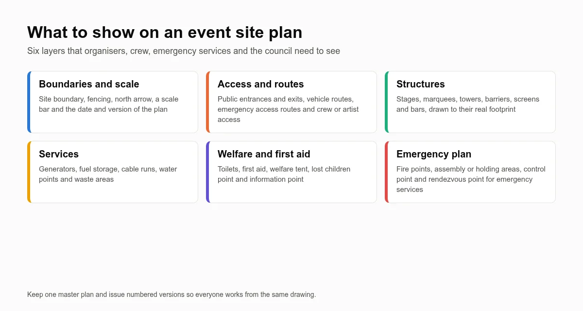
Boundaries and basics
- site boundary and fence lines, including the type of fencing
- north arrow, scale bar and a key
- event name, plan version number and date
Access and routes
- public entrances and exits, with widths
- emergency vehicle access routes, kept clear at all times
- production, crew and artist access, and where trucks load and turn
- car parks, drop-off points and pedestrian routes from them
- accessible routes and viewing areas
Structures
Stages, marquees, gazebos, towers, screens, barriers and bars, drawn to their actual footprint including guy ropes and ballast. Leave enough space around structures for safe building, and for the crowd to move. Our guide to planning load-in and load-out explains why access to each structure matters during the build.
Services
Generators, fuel storage, distribution boards, cable runs and crossings, water points, and waste and recycling areas. Keep generators and fuel away from public areas and structures, and show where cables cross routes so ramps can be planned.
Welfare and first aid
Toilets (including accessible units), first aid points, welfare and lost children points, information points and drinking water.
Emergency arrangements
Fire points and extinguishers, evacuation routes, assembly or holding areas, the event control point and a rendezvous point for emergency services. If you use a grid reference system so staff can describe locations quickly, overlay it on the plan. Government guidance on fire safety responsibilities applies to events as well as permanent premises.
Who needs which version
| Audience | What they need |
|---|---|
| Safety advisory group, council and emergency services | The full plan, with routes, capacities, emergency arrangements and welfare |
| Production and build crew | Structure positions with dimensions, truck routes, loading points and build order |
| Stewards and security | A simple version with entrances, exits, first aid, control and response points |
| Suppliers and traders | Their pitch, access times and route on and off site |
| The public | A clear, simplified map of attractions, toilets, food, first aid and exits |
Keep one master plan and produce the other versions from it. Every time something changes, update the master, give it a new version number and reissue it. Old plans in circulation are a common cause of mistakes on build day.
Link the plan to your other documents
Your site plan, risk assessment and event management plan should tell the same story. If your event risk assessment says vehicles and pedestrians are kept apart, the plan should show how. If your bad weather plan moves people into a marquee during a storm, the plan should show the route. If you have given a Temporary Event Notice, the area it covers should match. HSE’s event safety guidance and The Purple Guide both cover site design in more depth.
Common mistakes
- Not drawing to scale, so structures do not fit on the day
- Forgetting guy ropes, ballast and the space needed to build
- Emergency routes that are blocked by parked vehicles or traders
- Ignoring ground conditions, so trucks get stuck after rain
- Several versions in circulation, with no version number or date
- A plan that looks good on paper but has never been checked by walking the site
Crew who can read a site plan
Idloes Stage Crew provides experienced event crew across Mid Wales, Shropshire and the borders, from marking out and fencing to stage builds and site breakdown. See our services, meet our crew, book online or contact us to talk through your event.